Remnants of three September hurricanes that ravaged Florida
brought areas in Georgia up to 8 inches of rain and 58
mile-per-hour winds, according to data collected by the University of
Georgia.
The UGA Automated Environmental Monitoring Network is a network
of 60 weather stations across the state. The stations monitor
daily rainfall and wind speeds and much more.
Each station monitors air and soil temperature, relative
humidity, solar radiation, air pressure and wind direction. The
information is updated at least hourly and posted to the
network’s Web site (www.Georgiaweather.net).
Over a half a foot of rain
According to AEMN data, Frances brought the most rain to south
Georgia towns. The most rain from Frances fell on Tifton, where
the system recorded 6.8 inches. The storm brought 6.4 inches to
McRae, 6.2 to Nahunta, 5.8 to Vidalia and 5.2 to Camilla and
Albany.
The AEMN stations show that Ivan’s greatest rainfall
concentrations fell on central and north Georgia. Ellijay got the
most rain (7.8 inches), while Alpharetta had 5.7 inches, Dunwoody
5.5 and Georgetown 5.1. Atlanta had 4.1 inches from Ivan, and
metro-area cities like Griffin (4.4) and Duluth (4.3) got a bit
more.
Jeanne brought 8.2 inches of rainfall to the south Georgia town
of Homerville. Alapaha recorded 6.4 inches, Tifton 6.0 and
Jeffersonville recorded 5.7 inches. In central Georgia, Eatonton
had 5.6. Atlanta had 4.3.
UGA professor Gerrit Hoogenboom said the AEMN weather stations
use a much more sophisticated collecting system than backyard
rain gauges.
“Each weather site has a rain collecting cup that collects
one-hundredth of an inch of rain and then tips to empty,”
Hoogenboom said. “The computer system records each tip to
determine how much rain fell on a given day at each site.”
Winds up to 58 mph
The tropical weather systems Georgians endured also brought high
winds.
Frances brought the strongest. AEMN-recorded wind speeds were
58.3 mph in Cairo, 54.7 in Attapulgus, 49.3 in Vidalia and 47.5
in Dixie, Dublin and Tifton.
Ivan’s winds appeared strongest in north Georgia, where the
system recorded winds at 56.5 mph in Atlanta, 52.9 in
Gainesville, 49.3 in Blairsville and 47.5 in Williamson.
The last September storm, Jeanne, brought winds of 54.7 mph to
Camilla, 52.9 to Albany, 49.3 to Alapaha and 47.6 to Atlanta.
Attapulgus, Fort Valley and Tifton tied with 45.8 mph winds.
Tropical weather systems are defined in part by the wind speeds
they produce, said State Climatologist David Stooksbury.
“A tropical storm is one that has maximum sustained surface wind
speeds between 39 and 73 mph. And a hurricane’s maximum sustained
winds are 74 mph or more,” he said. “A tropical depression has
maximum sustained surface wind speeds of 38 mph or less.”
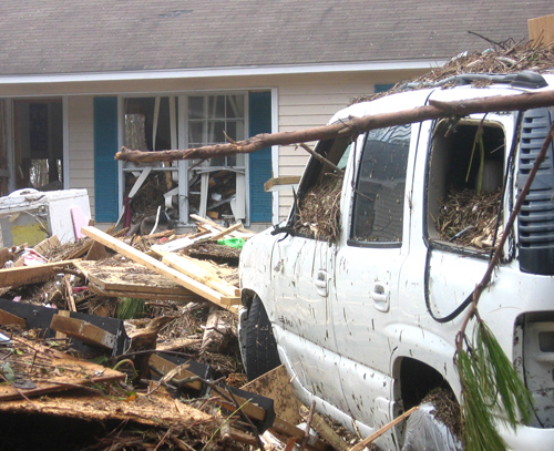
Floods often the result
Stooksbury says the damage a storm can cause is more important
than what it’s technically called.
“Alberto, in 1994, wasn’t a hurricane, but it totally flooded the
Flint River Basin and caused a tremendous amount of damage,”
Stooksbury said. “The take-home message in Georgia is the
flooding these storms can cause.”
The UGA weather network was developed in 1991. It’s the
brainchild of Hoogenboom, a faculty member with the UGA College
of Agricultural and Environmental Sciences.
Hoogenboom’s original goal was to have one station at each of
UGA’s nine agricultural experiment stations. Thirteen years and
60 weather stations later, Hoogenboom now hopes to eventually
have a station in every county.
“The first weather stations were installed for UGA scientists to
use for their research,” Hoogenboom said. “Now, every day we’re
hearing of new, unique ways people are using the real-time
weather data we collect, from helping predict propane demand to
helping farmers know the right time to apply chemical controls.”